What are Latitudes and Longitudes?
Mayank Sharma
- 2 Min To Read
- February 6, 2022
Latitude & Longitude - These are imaginary lines drawn on the globe.

Lines running east and west, parallel to the equator - These are called Lines/Parallels of latitude.
Lines running north and south passing through the poles - These are called Lines/Meridians of longitude
The intersection of latitude and longitude pin-points any place on the earth’s surface.
 Table of Contents
- Latitude
- Longitude
- Coordinates
Latitude
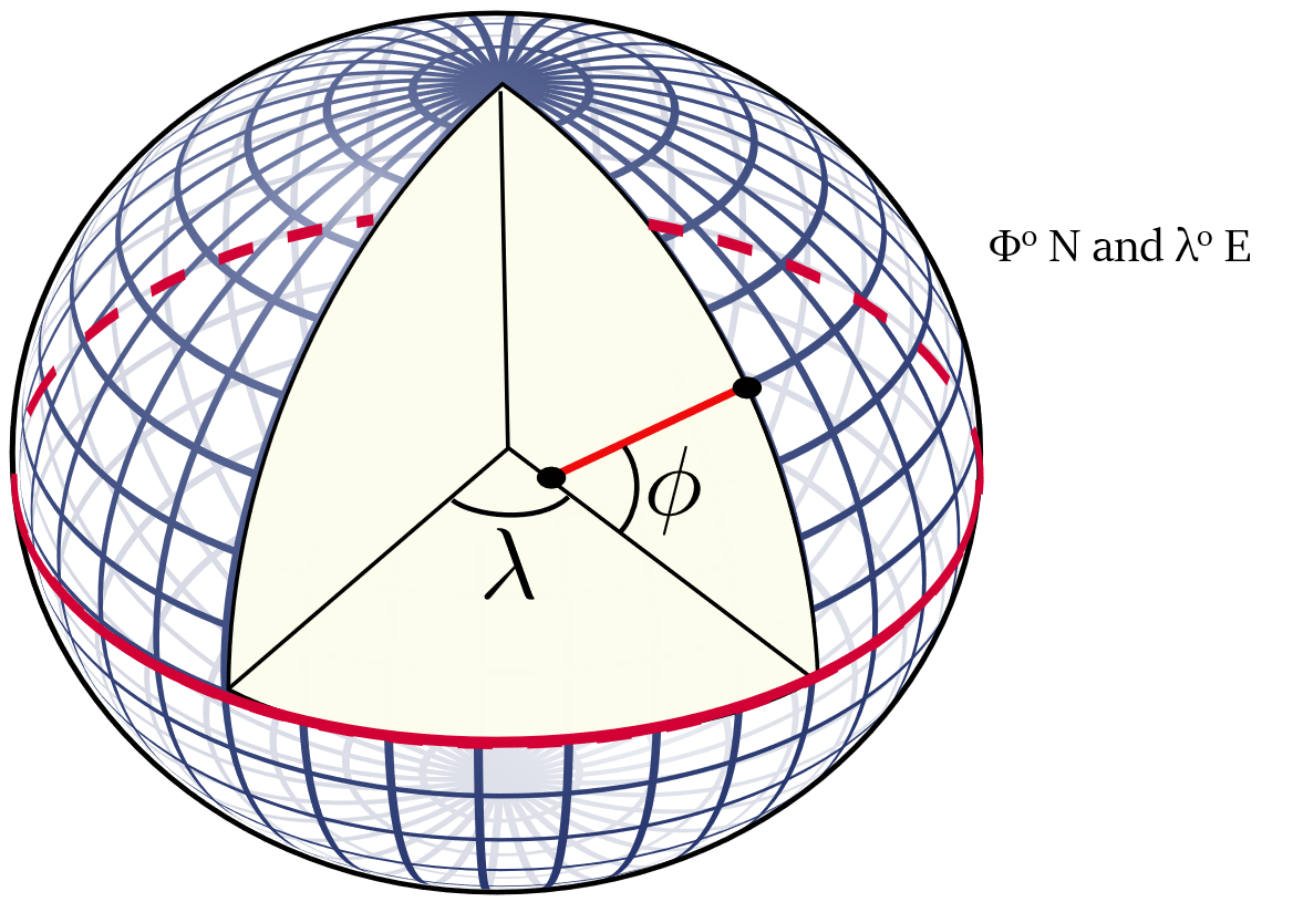
Latitude - angular distance (in degrees) of a point on the earth’s surface from the centre of the earth.

- Latitude lines or Parallels are parallel to the equator.
- They are circles which get smaller polewards.
- The equator represents 0° and the North and South Poles are 90°N and 90°S.
- Average linear distance of a degree of latitude = 69 miles (111 km)
- As the earth is slightly flattened at the poles, the linear distance of a degree of latitude at the pole is a little longer than that at the equator.
- Each degree is sub-divided into 60 minutes and each minute into 60 seconds.
The most important lines of latitude:

Longitude
Longitude - angular distance (in degrees) of a place east or west of the Prime Meridian.
 Prime Meridian / Greenwich Meridian
Zero meridian (0°) passes through the Royal Astronomical Observatory at Greenwich, near London.
All other meridians radiate eastward and westwards up to 180° from Prime Meridian.

- Lines of longitude/Meridians are a series of semi-circles that run from pole to pole (in a north-south direction) passing through the equator at right angles.
- Unlike latitudes, they are all equal in length.
- 1° of longitude = 69.1 miles at the equator and 1° of longitude = 0 miles at the poles.
- They determine local time in relation to Greenwich Mean Time (G.M.T.)/World Time.
Coordinates
The combination of meridians of longitude and parallels of latitude establishes a framework or grid.
Using this grid we can determine exact positions of any place in reference to the Prime meridian and the Equator.
To provide a geographic location of a place using latitude and longitude - Coordinates are used.
The latitude has the symbol of phi (Φ) & the longitude has the symbol of lambda (λ).

Latitude is always written first.
For example:
A point - 40° N, 30° E
It will be located 40° north of the Equator and 30° east of the Prime meridian.
To be even more precise - we should use minutes, and seconds along with degrees.
A point - 40° 35′ 26′′ N, 30° 12′ 38′′ E